Apropos of a conversation with another cyclist last night:
REMAP offers a taste of freedom
REMAP is a registered charity that has provided one-off technical aids that help disabled people of all ages to enjoy a better lifestyle for more than 30 years. Sometimes the smallest gadget or the simplest modification to a piece of existing equipment can make an enormous difference to somebody's life.
Case study:
A client with thalidomide, who was born without any arms, contacted REMAP as he had children and wanted to cycle with them, as well as get more exercise.
Engineers from REMAP used a recumbent tricycle to design and build a bicycle which gives the client full control in a safe manner. Wherever possible proprietary parts were used or modified, but the frame and many other parts had to be made from scratch. The tricycle is steered by rotating the shoulders, the brakes are foot operated — it has a hydraulic disc brake at the rear and conventional caliper brake at the front — and the eight gears are operated by the inside of the knees. It has battery-powered turn indicators.
The client can now accompany his children on cycle rides and get good cardiovascular exercise.
(agenda: News and events from the Institution of Mechanical Engineers 3. 7 (2004): 5.)
How to get home faster if your bottom-pull front derailleur cable snaps and you did not bring along a spare. (I did this because I am in the midst of changing Ivy's housing and cables, and desired to clean my chain using Pedro's Chain Machine.) A more secure method would be to remove the cable cinch bolt (Watch that little metal washer / tab!) and thread the cable tie through it. Another rider, who did not have cable ties, managed it with a shoe lace, a significantly more difficult operation since it stretches a lot more.
Note: top-pull front derailleurs will no doubt require longer (or more) cable ties as the securing point will be the juncture of the seatstays and top tube.
Loctite™ 242 is a thixotropic (gel state at rest, liquid state when agitated), acrylic-based liquid that cures into a solid in the absence of air, or in contact with metal. It is commonly used in the automotive industry. Hobbyists and bicycle manufacturers frequently also use them. E.g. Santa Cruz Bicycles. It is very useful in preventing bolts and nuts from loosening under vibration. E.g. derailleur pulley bolts.
Loctite™ 242's qualities, however, may be compromised by the presence of oil, grease or other contaminants. Enter the Loctite™ 243, an oil-resistant version of Loctite™ 242. While cleaning fasteners of oil and grease contaminants is a good practice, a threadlocking compound with oil-resistant characteristics makes for good insurance. In addition, Loctite™ 243 also possesses a slightly higher cure strength:
Tips: to prevent clogging, avoid having the applicator nozzle come in contact with metal (e.g. bolt, nut, etc.). Spills and excess may be removed with acetone.
There is a price for the added insurance (of course): while the 50 ml bottle of Loctite™ 242 cost SGD$22 (US$14.41), the 10 ml bottle of Loctite™ 243 cost SGD$14.55 (US$9.54). This means Loctite™ 243 costs 3.3 times more than Loctite™ 242.
A characteristic of Loctite™ 243 that is not mentioned in the Data Sheet is its higher viscosity. In its uncured state, Loctite™ 242 behaves like a liquid, while Loctite™ 243 is more of a gel.
An image from a month-long, self-supported, mountain biking tour of East Java, Indonesia, in November 1992.
A peek inside the crater of an active volcano, Kawa Ijen, in East Java, Indonesia. The mist is a combination of sulphur fumes and water vapor from the simmering turquoise lake.
The volcano belches red rivers of molten sulphur; workers channel the liquid into cavities in the ground, where, upon solidifying, the huge blocks are broken into large chunks with sharpened steel bars and carried down the mountain. Each load of two bundles easily tips the scale at 70 kg (154 lbs). The locals are paid US$1.40 per 16 km (10 mile) trip.
We descended into the crater and observed the operation for about 20 minutes. After we climbed back out, we found ourselves digging sulphur crystals from our nostrils.
Guy Kawasaki visits Trek. For his write up, click on the image or here.
Hat tip to my housemate in NorCal, Big Nick, who rides a wicked 61 cm Specialized Hardrock, with a 150 mm Ritchey Logic Stem, and a 410 mm Thomson Elite seatpost.
Squinty was of no help. He probably enjoys Dean Martin's jokes too. (Hey, what's the feline equivalent of "booze hound"?)
The Munda Biddi Trail ("path through the forest" in Nyoongar Aboriginal language) is currently 1/3 complete: Stage 1 meanders 332 km (207.5 miles) from Mundaring to Collie over rolling terrain and takes between 7 to 10 days to comfortably complete. With the addition of Stages 2 and 3, this bush cycling trail will run 900 km (562.5 miles) to Albany, by the Southern Ocean. Official blurb here.
3-Map Pack of Stage 1. The maps regularly undergo revisions and updates; hence, make sure you have the latest copy. For example, Map 1 in the 3-map pack is edition 5, while Map 1 that is sold separately is edition 6. The Off-Road Cycling Guide is of limited value to experienced tourers.
Huck it! This reminds me of Henry W. Coe State Park. Across Highway 101 from Specialized in Morgan Hill, river crossings, overnight epics, trailers and panniers are part of the experience it offers. I guess this means the autarky-challenged, the self-styled prima donnas, and the Lance-Armstrong-wannabe-race-queens (who require support crew, cheerleaders, hugs, et cetera), should stay home :-P
:-D
Map 1a of Stage 1. Note: the map is incomplete and portions have been deliberately blurred or omitted to discourage cheapskates. Also, this is an (older) edition 5 map.
Elevation profile of Map 1a. Distance in kilometers and elevation in meters. (1.6 kilometers = 1 mile. 1 meter = 3.28 feet.)
Map 1b of Stage 1. Access to, and usage of, the Munda Biddi Trail is free. All proceeds from map sales are used to support the trail. The maps are printed on rip-proof plastic. If you plan to ride it, buy it.
Elevation profile of Map 1b. Distance in kilometers and elevation in meters. (1.6 kilometers = 1 mile. 1 meter = 3.28 feet.)
The ride begins in the Shire of Mundaring. The Nyoongar Aboriginals call this area, which lies 300 meters (984 ft) above sea level, "Mindah-lung," "a high place on a high place." More than a century old, the Mundaring Hotel lies a stone's throw from the beginning of the Munda Biddi Trail.
Across Jacoby Street is the Mundaring Community Sculpture Park, formerly the Mundaring Railway Station; to its rear, lies the northern terminus of the Munda Biddi Trail. Set in the style of railway sleepers, the sign is flanked by eucalyptus gum nuts, and scented by sprigs of sweetly fragrant Golden Wattle (Acacia pycnantha), Australia's national flower.
A closer look at the eucalyptus seeds or "gum nuts." A fountain in Kalamunda is modeled after this.
For those of us who were scouts:
What is a Woggle?
Every Scout knows but a stranger may not. You may know the Australians by their uniform . . . one distinctive feature is in place of a scarf knot, the Australians all have their scarves fastened with a "woggle," which is being interpreted is an Australian gum nut, the fruit of the Eucalyptus gum tree.
(Official Souvenir Handbook for the Coming of Age Jamboree, held at Arrowe Park, Birkenhead, in 1920)
Another trail, the 16.6 km (10.4 mile) Mundaring Loop, also runs through here.
Point L on the Mundaring Loop Map, above the Mundaring Hotel (marked "Hotel").
Info shed. Taking a page from someone I choose to idolize, I opt to travel ultra-light — sans tent, sans sleeping bag, sans lantern — eschewing comfort and convenience for speed. Pack weight with 1.5 liters of water is a huckable 6.7 kg (14.74 lbs).
The start of the Munda Biddi Trail.
'Sent a copy of this to the guys at Cupertino Bike Shop. Vance is an incredible rider, he came in 2nd in the Davis Double Century (320 km) with a time of 8 hours 46 minutes. That's an average speed of 22.8 mph (36.5 km/h) over 200 miles (320 km) ^_^
Although its tracks are long gone, the railway continues to dominate the landscape: the old platform remains, with the first few hundred meters or so leading to the Railway Heritage Trail.
I was having too much fun slipping and sliding on the pea gravel to notice this abrupt turn, and ended up following Kep Track ("Gep" is the Nyoongar word for "water") eastward towards Northam, a 75 km (47 miles) trail. I had loads of fun, but, with the mandatory backtracking in, the mistake cost me an hour.
Back on the correct trail.
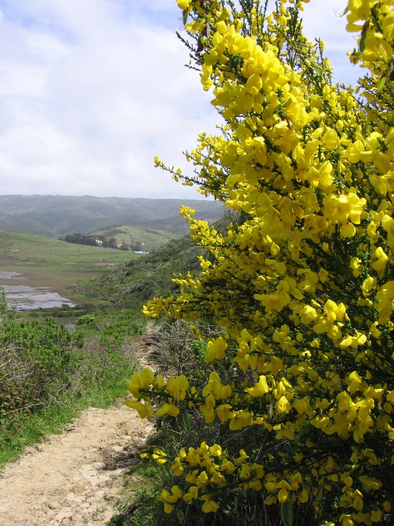
Wattles line the trail in golden swarths of the most brilliant yellow. The leaves on these are too small to belong to the Golden Wattle (Acacias pycnantha). These are more likely the Mulga Wattle (Acacias aneura). Its wood, harder than most other Acacias, was used to fabricate tools and weaponry by the Aboriginal people.
A closer look. They remind me of the bouquets of Scotch Brooms (Cytisus scoparius) along Estero Trail at Point Reyes, North California. Step up on a log among them and you will have your own maillot jaune.
The trail changes character infinitely. Here, it zigzags through trunks blackened by forest fires.
Then, you round a corner and become dazzled by an explosion of yellow crowns and living carpets of the most verdant green.
Of course, nothing is complete without climbing up the rolling hills of the Darling Scarp...
...with glades of swaying Hare's Foot Clovers (Trifolium arvense var. arvense) as your reward :-)
Further up, as lungs heave and legs burn, Blackboys (Xanthorrhoea) or grasstrees rustle in friendly encouragement.
Descending to Mundaring Weir Road.
Mundaring Weir Road. For those reluctant to shell out the clams for Mundaring Weir Hotel, there's the YHA Hostel.
Mundaring Weir Hotel. In the old days, when the trains called at Karda Mordo station, located higher up, beer kegs were unloaded and rolled down this very road to the hotel.
Speaking of kegs, these still come from Swan Brewery.
Entering the Shire of Kalamunda. In Nyoongar, "kala" means "home," and "munda," "forest." The eucalyptus gum nut has been adopted as its symbol.
Evidence of water shortage in this area is obvious. This is what the weir looks like when it is full.
Getting back on the trail.
Maybe it's my twisted sense of humor, but I found this sign hilarious; and, for the next hour or so, proceeded to torture the fauna with my rendition of Steppenwolf's "Born to be Wild."
Riding along North Ledge of the Mundaring Weir. Ivy's longer, L-bar ends proved to be a wise choice here.
Bibbulmun Track, a long-distance hiking trail, begins in this area, stretching 963 km (602 miles) from Kalamunda to Albany.
It looks like something I'd rather not say, and tastes worse. It gives you bad gas as well; kangaroos started dropping dead around me.
To put it in another way, I'd rather chew NoDoz™ pills and suck on an old coffee filter instead. Bleah!
Lunch: really bad coffee and a really good coffee bun.
A slight draft between my fingers revealed a tear in my left glove. I bought these wonderful Pearl Izumi gloves from Any Mountain, Cupertino in November 1996. I guess they had a good run.
Bumpy video. Mounting the camera on the handlebar does little for shock isolation. Maybe I should get a lipstick camera (but that would mean more weight to lug around, more batteries to run flat, and more things to break).
Directional arrows such as these, posted regularly, identify the trail.
A closer look.
This symbol indicates that you are on the Munda Biddi Trail.
This directional symbol indicates a major change in direction ahead.
Other trails sometimes cut across or share the Munda Biddi Trail.
Pea-flowers (Fabaceae). A legume, like the peanut, when its petals flutter in a breeze, the shrub looks as if it's on fire.
Singletrack in a Jarrah (Eucalyptus marginata) forest. Jarrah wood, when green, is denser than water. Note to Dr. Watson, "Do not chop these for canoes."
Another bumpy video. I thought of mounting the camera on my helmet but was concerned about:
a) compromising the safety features of the helmet (you may think Dr. Frankenstein's monster looks cool with bolts in his head, but lets see you clear airport security);
b) getting the assembly whacked off by a low branch.
Pea gravel. These rocky spheroids can accumulate to a-foot-deep (30 cm) or more on trails. The locals liken the experience to riding on ball-bearings — I concur. Subaru World Rally Team Championship principal, David Lapworth, also expressed the same opinion.
The sound of tires rolling over the hard, loose beads is rather unique, similar to jiggling a jar of small, hard seeds or AirSoft™ pellets. Fortunately, the winter rains have packed these tiny spheres down somewhat; in summer, my 2-inch-wide Specialized Roll-X Pros are likely to be too skinny.
The guys at the bike shops here deemed Ivy, "old school hardcore." Hmm... Is she really hardcore? I mean, what about this bike? It looks about ready to take on a Star Destroyer.
Tip for tourers: the awl in a Swiss Army knife safely enables the release — and reuse — of zip / cable ties.
Speaking of old school. How many people owned a Cateye CC-8000 ATC? This doesn't belong to me. My Cateye ATC is somewhere along Woodcutter's Trail, whacked off by a kleptomanic branch in 1995.
Umm... okay.
I don't think the headbolts unscrewed by themselves and the cylinder head went waltzing Matilda. Anyone want to handcrank this sucker over? Come on, it would be a piece of cake! There's no compression! :-D
Now that's what I call a gutted interior :-P
The parking brake is still engaged, but I don't think this sad heap is going anywhere.
Time for dinner and settle in for the night. With this special light, I see all sorts of things. I even see...
Oops! Forgot to set the flash to automatic. There you go.
Next day, more singletrack. There's a low branch in there somewhere.
Occasionally, the trail skirts the boundaries of farms and orchards.
A vineyard.
Fresh lemonade.
Fresh... umm... degreaser? :-D
Spurs off the main trail that are reserved for hikers are cordoned off with barriers, and — more importantly — reflectors. Bare wood is practically invisible at night to cyclists. A reflector could mean the difference between a bone-breaking crash over the handlebar and a safe stop. This one time, at band camp while descending Mount Tamalpais (1), (2), experience portend it an impossibility the absence of a physical barrier between an off-road trail and an asphalt, public road. Sure enough, when I stopped and carefully walked up, my lower thighs knocked into a log barrier. The wood had weathered black, rendering it all but invisible to most bicycle headlights (which are generally anemic anyway).
One more video: a nice, long, gentle downhill through a Jarrah forest.
Epilogue: Total distance: cyclo-computer 73.9 miles (118.2 km) / GPSdead Total elevation climbed: Altimeter 6361 ft (1939 m) Temperature range: 53 F to 70 F (11.7 C to 21 C)


